Esperanza High School site
Historical USGS topo maps
and links to other online materials about the site
Historical map data are available via web interface at
http://historicalmaps.arcgis.com/usgs/
and as downloads in many formats from the federal government at
http://ngmdb.usgs.gov/maps/TopoView/
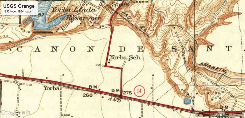
Image 296372.jpg
Terminal station of the Pacific Electric Railway had been completed to
the point shown on this map by 1911 or 1912.
The station was named for Jacob Stern, the man who acquired the land
from the Yorba family.
Topography shows pit not yet excavated, but end of the rail line well
positioned for loading gravel and transporting it to LA.
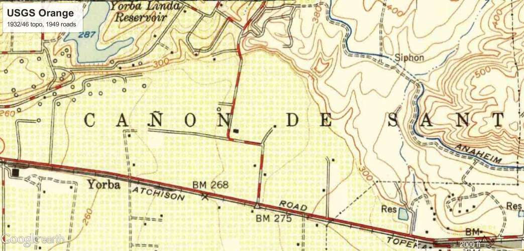
Image 293738.jpg
Railway is gone.
Documents about the Pacific Electric indicate that it had been out of
service since 1938, and the EPA report indicates that the petroleum
refinery waste dumping started in 1940.
There is a road in the site of the gravel pit that is consistent with
digging, but the topography is not updated to show the pit.
The EPA report mentions a contaminated water well in 1947 at a
location that is consistent with the house in the orange grove.
EHS handball courts currently occupy that spot.
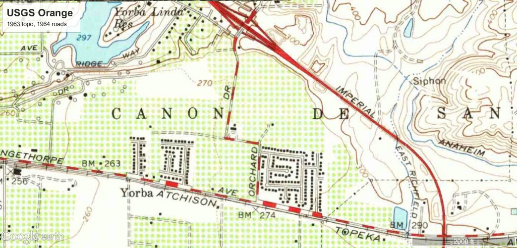
Image 293739.jpg
Topography now shows the excavated pit.
Imperial Highway exists on old rail right of way.
Conversion of orange groves to houses has begun.
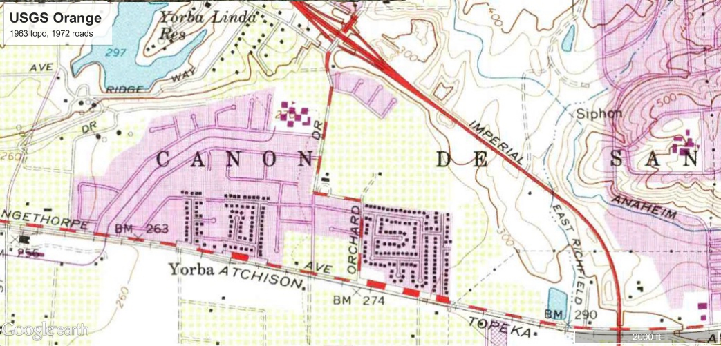
Image 293740.jpg
More housing development, Orchard School exists, EHS site is still an
orange grove.
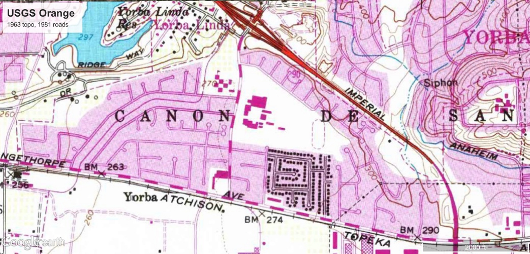
Image 293742.jpg
EHS is built, neighborhoods are developed all around.
Historical Aerial Photos of the region from 1946 to 2012
are available from
http://www.historicaerials.com/?javascript=&scale=3&year=1946&lat=33.872&lon=-117.802
CSUF Oral History Program
Yorba Linda Community History Project
Remembrances of Yorba Linda's Early Years
Daniel L. Hoppy, November 14, 1968 and January 8, 1969
and
John Tugwell, April 26, 1972
Interviews with George Kellogg, the man who planted the orchard
on which Esperanza High School was built.
Also tells the story of Jacob Stern, the man for whom the terminal
station of the Pacific Electric Railway was named.
http://www.yorbalindahistory.org/gsdl/cgi-bin/library?e=d-000-00---0tescol--00-0-0--0prompt-10---4------0-1l--1-en-50---20-home---00031-001-1-0utfZz-8-00&a=d&c=tescol&cl=CL1&d=HASH01ab97cdf0969ae7bc5a4415.11#start
EPA report about the contaminated well and the toxic cleanup
see pages 6, 47 to 50, 98 to 99
http://nepis.epa.gov/Exe/ZyPURL.cgi?Dockey=30000FX0.txt
This EPA writeup was based on documents from the California Department
of Health Services (CDHS).
(CDHS was reorganized in 2007 resulting in creation of the
California Department of Public Health (CDPH).)
Agencies mentioned as part of those documents are
California Regional
Water Quality Control Board and the County of Orange Human
Services Agency (which, to no surprise, has also been reorganized).
Another anecdote about sulfur dioxide emissions during the cleanup at
Journal of the Air and Waste Management Association
John A. Wood & Michael L. Porter (1987),
Hazardous Pollutants in Class II Landfills,
JAPCA, 37:5, 609-615, DOI: 10.1080/08940630.1987.10466250
http://www.tandfonline.com/doi/abs/10.1080/08940630.1987.10466250
Most of the live online EPA information seems unlikely to have been
updated in the 20 years since the zip code changed.
EPA Enforcement and Compliance History Online (ECHO)
Detailed Facility Report
110006468571
https://echo.epa.gov/detailed-facility-report?fid=110006468571
EPA Facility Registry Service (FRS)
Facility Detail Report
110006468571
https://oaspub.epa.gov/enviro/fii_query_dtl.disp_program_facility?p_registry_id=110006468571
Resource Conservation and Recovery Act (RCRA)
Facility Information
CAD980637888
https://oaspub.epa.gov/enviro/rcrainfoquery_3.facility_information?pgm_sys_id=CAD980637888
From page 96 of the 1983 Quetzal yearbook as seen at
http://www.e-yearbook.com/yearbooks/Esperanza_High_School_Quetzal_Yearbook/1983/Page_96.html
Toxic waste causes death Relatives of a San Clemente resident who died
after being exposed to hazardous waste from the Kellogg Terrace toxic
dump site, filed a wrongful death suit in Orange County court against
the Shupe Trucking Company alleging that the driver of the truck,
whose job it was to deliver the toxic waste being taken from the
dumpsite near the school campus, did not take precautions to wash out
the waste at the legal dumpsite in Kettleman Hills. The driver
allegedly drove his truck back to San Clemente and cleaned the truck
there. Charles Dunston, who lived adjacent to the area where the
truck was hosed out, reported respiratory problems and died at Camp
Pendleton's hospital within 48 hours of being exposed to the waste.
Birth and death information about Navy Commander Charles Edward Dunston are at
http://www.genealogy.com/ftm/s/h/u/Jack-D-Shultz/WEBSITE-0001/UHP-0510.html
DropBox full of newspaper clippings and other documents from
Lisa Pruitt-Star
https://www.dropbox.com/sh/v1soncgt9qnbxbn/AAD6WNWj36BRMfCeQQVY4tgia?dl=0
Information gathered by the facebook alliance...
Contamination from the EHS auto shop oil tank,
its cleanup, and the monitoring well that was put there by USGS.
http://geotracker.waterboards.ca.gov/profile_report.asp?global_id=T0605902321
Note in particular the
detailed report that gives water test results.
At that location the groundwater contamination could be a mix of
things from the EHS auto shop tank and the Kellogg Terrace site.
The report also references the nearby
Concerto Investigation into water wells possibly contaminated by
gas stations at Imperial and La Palma and also Esperanza and Fairlynn.
Also on the state water board geotracker is a misplaced marker for the
gas station which was once at the KT site.
Its documents hint that it was opened in 1950 and closed in 1965.
Note also that there is not anything in the state water board database
about the KT site even though the EPA report above contains
information about the contaminated well on the site of EHS.
Location of the Ballad and Concerto wells is shown here
https://drive.google.com/file/d/1tqHOx7wzwhGae72HYy5XgsOUML0/view?pref=2&pli=1
More details on the water system in that area are at
https://sdwis.waterboards.ca.gov/PDWW/JSP/WaterSystemFacilities.jsp?tinwsys_is_number=3385&tinwsys_st_code=CA
The Ballad well tests are at
http://geotracker.waterboards.ca.gov/gama/gamamap/public/GamaDataDisplay.asp?dataset=DHS&samp_date=&global_id=W0603010070&assigned_name=3010070-001&store_num=ALL&orderby=SAMP_DATE
Ballad well seems to have been shut down by 1999.
The Concerto #1 tests are at
http://geotracker.waterboards.ca.gov/gama/gamamap/public/GamaDataDisplay.asp?dataset=DHS&samp_date=&global_id=W0603010070&assigned_name=3010070-002&store_num=ALL&orderby=SAMP_DATE
Concerto #1 seems to have been shut down by 1999, and was destroyed in 8/04.
The Concerto #2 well tests are at
http://geotracker.waterboards.ca.gov/gama/gamamap/public/GamaDataDisplay.asp?dataset=DHS&samp_date=&global_id=W0603010070&assigned_name=3010070-003&store_num=ALL&orderby=SAMP_DATE
Concerto #2 seems to have been shut down by 2010.
This was right after the 6000 feet of 16-inch water main were
"fast-track" installed along Orangethorpe from Van Buren to Boisseranc
in order to connect Golden State Water Company Yorba Linda to the
wells that supply Golden State Water Company Placentia.
Maps of water system boundaries are at
http://cehtp.org/page/water/water_system_map_viewer
and also by choosing "Public Water Systems" at
http://geotracker.waterboards.ca.gov/map/?CMD=runreport&myaddress=33.87613520938913%2C+-117.79099323928222&zl=15
Steve Allen <sla@ucolick.org>